|
|
TODAY.AZ / Weird / Interesting
How smartphones are improving city life in Singapore
25 June 2015 [15:39] - TODAY.AZ

Throughout cities around the world, digital information is readily shared and collected through smartphones, tablets, sensors and other communication devices that have become part of everyday life.
But in the streets of Singapore, this amounting of "big data" will soon be used to improve urban life through LIVE Singapore! -- a project that uses real-time data to track and affect the activity of a city.
"We can analyze the pulse of the city, moment to moment," says Carlo Ratti, Director of the MIT Senseable city lab, which runs the project as part of the Singapore-MIT alliance for Research and Technology (SMART).
"Over the past decade, digital technologies have begun to blanket our cities, forming the backbone of a large, intelligent infrastructure," says Ratti, who believes cities have become open-air computers storing information that should be harnessed and tapped into.
The team are exploring the use of data in Singapore due to its unique existence as a city, nation and island.
"It becomes an ideal lab to study the link between technology and city planning," says Ratti.
Solar-powered 'supertrees' breathe life into Singapore's urban oasis
Traffic, crowds and rainfall
By tapping in to real-time information about their city, Singaporeans could make day-to-day decisions based on their environment -- creating a feedback loop between people, their actions and their city -- whilst simultaneously contributing to the data they are collecting.
Such feedback can impact factors influencing daily life, ranging from overcrowding and traffic jams to temperature control and taxi availability. The more data available, the more impact it can have.
"The power increases exponentially," says Ratti.
One example is the monitoring of mobile phone use throughout the city-state to track the movements of people and provide information about crowding.
According to the MIT Senseable city lab, mobile phone penetration in Singapore is more than 140%, as people own more than one mobile phone.
By using data from cell phone networks in Singapore, maps can be created to visualize where usage is highest -- and therefore where the number of people is highest.
The use of urban space can be revealed in real-time.
A more environmental example is the tracking of people and vehicles during rainfall. Singapore's tropical climate means rainfall is frequent and torrential.
"The local weather has a major impact on the behaviour of a population," says Gerhart Schmitt, Professor of Information Architecture and Founding Director of the Singapore-ETH Centre in Singapore. "[It is] at the same time influenced by and influencing the population," he says.
Schmitt's center are developing a range of visualization technologies to inform users about factors such as air quality -- when planning a route to walk -- or traffic jam prediction.
Tailored Taxis
According to Schmitt, taxis make up almost 1/5 of the car transportation load in Singapore and numbers are expected to be similar in other high-density cities worldwide.
"It's important...to visualize the availability of taxis," says Schmitt.
For LIVE Singapore, Ratti's team have combined this demand for taxis with the city's climate. Their sample visualization blends taxi locations and rainfall data to enable the development of apps helping locals hail taxis during a downpour.
The use of this form of data is somewhat limitless with potential and has also been used to visualize temperature hotspots based on the 'heat island' effect where buildings, cars and the use of cooling units causes temperatures to rise, as well as broader scale information such as the global reach of Singapore's ports and airports.
Schmitt's teams are exploring the uses of public transport data generated from smart-card based ticketing systems now common across the world and further researching the urban heat island effects in Singapore, which they believe will eventually reduce liveability. "[It] has become quite serious," he says
Is there an app for that?
For now, Ratti is mainly showing the potential uses of big data generated within a city like Singapore but his goal is to make the data more readily available, and accessible, to create a platform on which others access the data and create new apps tailored to the city's needs.
"The way it will change people's lives is through different types of apps," says Ratti. "LIVE Singapore! can start ideas for combining data, which can become apps," he says.
This is the goal of Ratti's follow-up data project -- data collider -- due to launch publicly in 6 months as a broader platform to spark new ideas.
"Anybody can use it to visualize and explore the data and learn more about their city," he says.
URL: http://www.today.az/news/interesting/141718.html
 Print version
Connect with us. Get latest news and updates.
See Also
- 29 June 2026 [08:00]
Marie Curie's notebooks remain radioactive more than century later - 28 June 2026 [20:00]
Shahdag Tourism Center opens summer season with new opportunities for visitors - 28 June 2026 [19:15]
Shirvan Plain: Living landscape of rare plants and changing ecosystems - 28 June 2026 [14:05]
Azerbaijani culinary heritage and culture highlighted in France - 31 May 2026 [14:19]
Shamakhi Astrophysical Observatory releases space weather forecast - 31 May 2026 [13:30]
Azerbaijan plans major step in digital development with Supercomputer Center - 26 April 2026 [23:00]
Time to apply brakes to runaway AI, says pioneer - 26 April 2026 [22:23]
Chinese scientists discover two new lunar minerals - 19 April 2026 [00:18]
Swedish king controversy reveals monarchy’s democratic contradiction - 09 April 2026 [14:25]
Lyrid meteor shower to light up sky
Most Popular
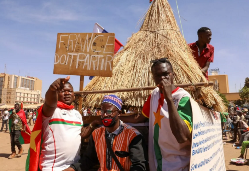 And Burkina Faso slammed the door: the collapse of French politics in Africa
 Paris wanted to enter the Middle East without knocking – and got it from Tehran
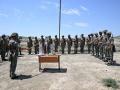 Azerbaijan Army enhances officer training with specialized demonstration classes
 To revive the "dead man" - who and how in Armenia is holding on to the separatist project
 Europe remains critical hub for U.S. military operations, Rutte says
 Ukraine expands deep-strike campaign with attacks on Russian military sites
 Ukraine seeks French license to produce SCALP cruise missiles